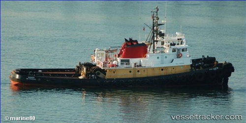
.
Vessel photo of Ranger (IMO 7505994) vesseltracker.com

Ranger

Vessel type: Tug | IMO: 7505994 | MMSI: MMSI: 366748410
Call sign: WBN5979 | Dimensions: 10 m x 40 m
Current Status

Where is the vessel?

Ranger is currently in Near Blount Island, based on AIS data received about 1010d ago.

Latest AIS update:

Current position: 30.41680° N, 81.53593° W (Near Blount Island)

Average speed (last 7 days): Loading…

Average speed (last 30 days): Loading…

Vessel profile: Ranger is a Tug with dimensions 10m x 40m.

This page combines live AIS, route history, probable destination signals, nearby traffic, and port activity for practical vessel monitoring.

The current position of vessel Ranger is 30.41680 lat / -81.53593 lng. Updated: 2023-07-12 13:07:18 UTC
Nearest reference points:
  • Near Jacksonville
  • Near Fernandina
  • Near Ponte Vedra
Details:

Live Vessel Ranger Analytics (details, animations, etc.)


Recent AIS points (UTC):
2023-07-12 13:07:18 UTC · 30.41680, -81.53593 · SOG 0 kn · COG 0°

Track of the vessel in the last 60 days


UTC: --
Start: -- Track timeline (UTC) End: --
Encountered: --


Link to the map:


Find another ship

Ranger (366748410) last ports (portcalls and passsages)

Jacksonville | 2023-01-05 23:54:40
Jacksonville | 2021-12-02 20:46:13