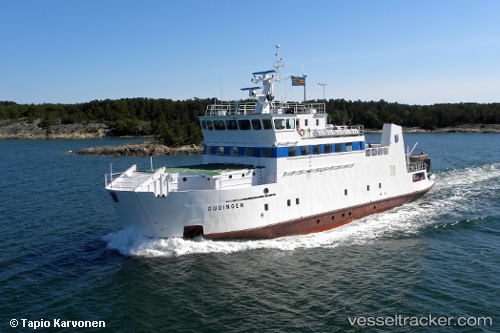
 Gudingen
Current Status
Where is the vessel?
Gudingen is currently in Near LANGNAS, based on AIS data received about 15h ago.
Latest AIS update:
Current position: 60.11796° N, 20.29628° E (Near LANGNAS)
Average speed (last 7 days): Loading…
Average speed (last 30 days): Loading…
Vessel profile: Gudingen is a Passenger Ro Ro Cargo Ship with dimensions 48m x 10m.
This page combines live AIS, route history, probable destination signals, nearby traffic, and port activity for practical vessel monitoring.
The current position of vessel Gudingen is 60.11796 lat / 20.29628 lng. Updated: 2026-05-24 23:26:19 UTCNearest reference points:
- Near Finström
- Near Maarianhamina (Mariehamn)
- Near MARIEHAMN
Currently sailing under the flag of Finland ![]()
Gudingen built in 1980 year
Deadweight:
230 tDetails:
Live Vessel Gudingen Analytics (details, animations, etc.)
Recent AIS points (UTC):
2026-05-24 19:59:39 UTC · 60.11795, 20.29622 · SOG 0 kn · COG 1°2026-05-24 21:47:49 UTC · 60.11799, 20.29619 · SOG 0 kn · COG 1°
2026-05-24 22:11:58 UTC · 60.11798, 20.29628 · SOG 0 kn · COG 1°
2026-05-24 23:26:19 UTC · 60.11796, 20.29628 · SOG 0 kn · COG 1°