 ANDREA
Current Status
Where is the vessel?
ANDREA is currently in 39 nm NE of Somersby, based on AIS data received about 14h ago.
Latest AIS update:
Current position: 53.50333° N, 1.96167° E (39 nm NE of Somersby)
Average speed (last 7 days): Loading…
Average speed (last 30 days): Loading…
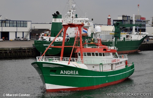
Vessel profile: ANDREA is a Search and Rescue vessel with dimensions m x m.
This page combines live AIS, route history, probable destination signals, nearby traffic, and port activity for practical vessel monitoring.
The current position of vessel ANDREA is 53.50333 lat / 1.96167 lng. Updated: 2026-05-20 13:17:02 UTCNearest reference points:
- 48 nm NE of Somersby
- 11 nm NE of Caister on Sea
- 24 nm NE of Caister on Sea
Currently sailing under the flag of San Marino ![]()
Details:
Live Vessel ANDREA Analytics (details, animations, etc.)
Recent AIS points (UTC):
2026-05-20 09:38:00 UTC · 53.51667, 2.03500 · SOG 1 kn · COG -1°2026-05-20 10:08:02 UTC · 53.50667, 2.00167 · SOG 2 kn · COG -1°
2026-05-20 10:56:00 UTC · 53.49167, 1.94667 · SOG 3 kn · COG -1°
2026-05-20 13:17:02 UTC · 53.50333, 1.96167 · SOG 4 kn · COG -1°