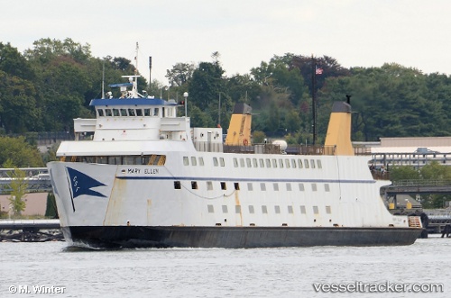
 Mary Ellen
Current Status
Where is the vessel?
Mary Ellen is currently in Near New London, based on AIS data received about 14h ago.
Latest AIS update:
Current position: 41.35542° N, 72.09162° W (Near New London)
Average speed (last 7 days): Loading…
Average speed (last 30 days): Loading…
Vessel profile: Mary Ellen is a Passenger Ro Ro Cargo Ship with dimensions 80m x 14m.
This page combines live AIS, route history, probable destination signals, nearby traffic, and port activity for practical vessel monitoring.
The current position of vessel Mary Ellen is 41.35542 lat / -72.09162 lng. Updated: 2026-05-19 13:43:36 UTCNearest reference points:
- Near PLUM ISLAND
- Near Springville, Suffolk
- Near JUDITH POINT
Currently sailing under the flag of USA ![]()
Details:
Live Vessel Mary Ellen Analytics (details, animations, etc.)
Recent AIS points (UTC):
2026-05-19 01:00:46 UTC · 41.15399, -72.24023 · SOG 0.2 kn · COG -1°2026-05-19 10:41:28 UTC · 41.15403, -72.24031 · SOG 0 kn · COG 315°
2026-05-19 11:25:07 UTC · 41.15404, -72.24032 · SOG 0 kn · COG 313°
2026-05-19 13:43:36 UTC · 41.35542, -72.09162 · SOG 0.1 kn · COG 111°