 vesseltracker.com
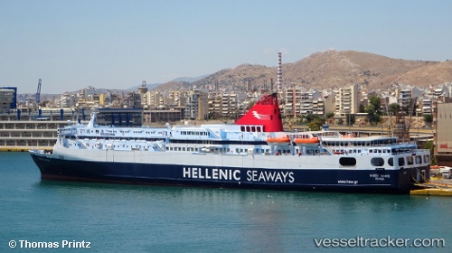
 Nissos Samos
Current Status
Where is the vessel?
Nissos Samos is currently in Near Piraeus, based on AIS data received about 14h ago.
Latest AIS update:
Current position: 37.94275° N, 23.62856° E (Near Piraeus)
Average speed (last 7 days): Loading…
Average speed (last 30 days): Loading…
Vessel profile: Nissos Samos is a Passenger Ro Ro Cargo Ship with dimensions 192m x 29m.
This page combines live AIS, route history, probable destination signals, nearby traffic, and port activity for practical vessel monitoring.
The current position of vessel Nissos Samos is 37.94275 lat / 23.62856 lng. Updated: 2026-05-18 05:55:38 UTCNearest reference points:
- Near Piraeus
- Near ZEA
- Near Drapetzona
Currently sailing under the flag of Greece ![]()
Nissos Samos built in 1988 year
Deadweight:
7622 tDetails:
Live Vessel Nissos Samos Analytics (details, animations, etc.)
Recent AIS points (UTC):
2026-05-18 02:19:26 UTC · 37.77443, 24.33914 · SOG 19.5 kn · COG 232°2026-05-18 03:54:32 UTC · 37.68081, 23.76701 · SOG 18.6 kn · COG 303°
2026-05-18 04:11:46 UTC · 37.75857, 23.71665 · SOG 18.6 kn · COG 331°
2026-05-18 05:55:38 UTC · 37.94275, 23.62856 · SOG 0 kn · COG 240°