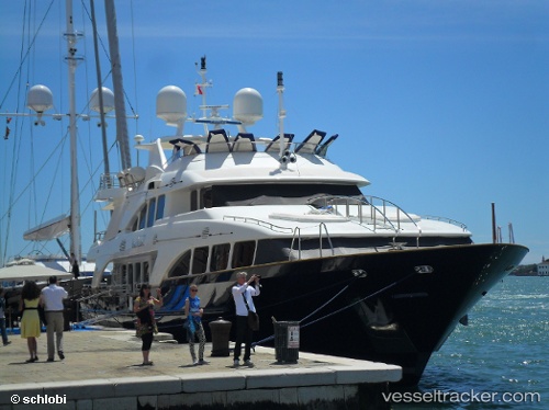
Seabluez
Current StatusWhere is the vessel?
Seabluez is currently in Near LA NAPOULE, based on AIS data received about 14h ago.
Latest AIS update:
Current position: 43.51470° N, 6.93911° E (Near LA NAPOULE)
Average speed (last 7 days): Loading…
Average speed (last 30 days): Loading…
Vessel profile: Seabluez is a Service Ship with dimensions 8m x 37m.
This page combines live AIS, route history, probable destination signals, nearby traffic, and port activity for practical vessel monitoring.
The current position of vessel Seabluez is 43.51470 lat / 6.93911 lng. Updated: 2026-05-20 11:50:51 UTCNearest reference points:
- Near Théoule-sur-Mer
- Near Boulouris-sur-Mer
- Near GOLFE JUAN
Details:
Live Vessel Seabluez Analytics (details, animations, etc.)
Recent AIS points (UTC):
2026-05-20 08:07:49 UTC · 43.51474, 6.93917 · SOG 0 kn · COG 288°2026-05-20 09:37:51 UTC · 43.51474, 6.93917 · SOG 0 kn · COG 288°
2026-05-20 10:25:50 UTC · 43.51473, 6.93916 · SOG 0 kn · COG 287°
2026-05-20 11:50:51 UTC · 43.51470, 6.93911 · SOG 0 kn · COG 288°