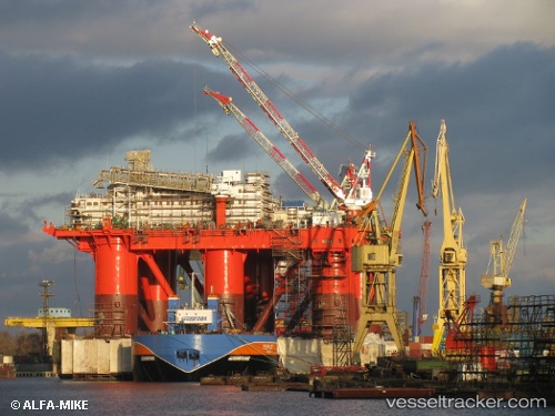
 Safe Caledonia
Current Status
Where is the vessel?
Safe Caledonia is currently in Near SCAPA, based on AIS data received about 16h ago.
Latest AIS update:
Current position: 58.91377° N, 2.98505° W (Near SCAPA)
Average speed (last 7 days): Loading…
Average speed (last 30 days): Loading…
Vessel profile: Safe Caledonia is a Service Ship with dimensions 92m x 70m.
This page combines live AIS, route history, probable destination signals, nearby traffic, and port activity for practical vessel monitoring.
The current position of vessel Safe Caledonia is 58.91377 lat / -2.98505 lng. Updated: 2026-05-19 19:48:43 UTCNearest reference points:
- Near Tingwall
- Near STROMNESS
- Near Staxigoe
Currently sailing under the flag of Singapore ![]()
Safe Caledonia built in 1982 year
Deadweight:
20930 tDetails:
Live Vessel Safe Caledonia Analytics (details, animations, etc.)
Recent AIS points (UTC):
2026-05-19 17:09:23 UTC · 58.91373, -2.98501 · SOG 0.1 kn · COG 189°2026-05-19 18:06:19 UTC · 58.91376, -2.98505 · SOG 0.1 kn · COG 189°
2026-05-19 19:48:43 UTC · 58.91377, -2.98505 · SOG 0 kn · COG 189°
2026-05-19 19:48:43 UTC · 58.91377, -2.98505 · SOG 0 kn · COG 189°