 Punta Gialla
Current Status
Where is the vessel?
Punta Gialla is currently in Near Taranto, based on AIS data received about 23h ago.
Latest AIS update:
Current position: 40.47760° N, 17.19891° E (Near Taranto)
Average speed (last 7 days): Loading…
Average speed (last 30 days): Loading…
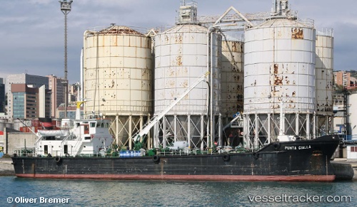
Vessel profile: Punta Gialla is a Service Ship with dimensions 52m x 52m.
This page combines live AIS, route history, probable destination signals, nearby traffic, and port activity for practical vessel monitoring.
The current position of vessel Punta Gialla is 40.47760 lat / 17.19891 lng. Updated: 2026-05-20 12:43:08 UTCNearest reference points:
- Near Marina di Ginosa
- Near Monopoli
- Near Porto Di Brindisi
Currently sailing under the flag of Italy ![]()
Punta Gialla built in 1989 year
Deadweight:
1448 tDetails:
Live Vessel Punta Gialla Analytics (details, animations, etc.)
Recent AIS points (UTC):
2026-05-20 12:43:08 UTC · 40.47760, 17.19891 · SOG 0 kn · COG -1°2026-05-20 12:43:08 UTC · 40.47760, 17.19891 · SOG 0 kn · COG -1°
2026-05-20 12:43:08 UTC · 40.47760, 17.19891 · SOG 0 kn · COG -1°
2026-05-20 12:43:08 UTC · 40.47760, 17.19891 · SOG 0 kn · COG -1°