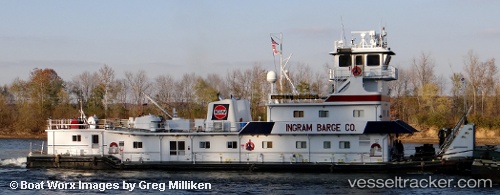
Ronald L Sensenbach
Current StatusWhere is the vessel?
Ronald L Sensenbach is currently in Near PADUCAH, based on AIS data received about 14h ago.
Latest AIS update:
Current position: 37.15996° N, 88.42784° W (Near PADUCAH)
Average speed (last 7 days): Loading…
Average speed (last 30 days): Loading…
Vessel profile: Ronald L Sensenbach is a Tug with dimensions 10m x 37m.
This page combines live AIS, route history, probable destination signals, nearby traffic, and port activity for practical vessel monitoring.
The current position of vessel Ronald L Sensenbach is 37.15996 lat / -88.42784 lng. Updated: 2026-06-17 01:27:28 UTCNearest reference points:
- Near Grand Rivers
- 16 nm E of Holly Springs, Marshall
- Near Olive Branch
Details:
Live Vessel Ronald L Sensenbach Analytics (details, animations, etc.)
Recent AIS points (UTC):
2026-06-16 21:42:01 UTC · 37.18523, -88.27900 · SOG 7.2 kn · COG 268°2026-06-16 23:49:19 UTC · 37.11270, -88.43555 · SOG 1.1 kn · COG 8°
2026-06-17 01:27:28 UTC · 37.15996, -88.42784 · SOG 0 kn · COG 339°
2026-06-17 01:27:28 UTC · 37.15996, -88.42784 · SOG 0 kn · COG 339°