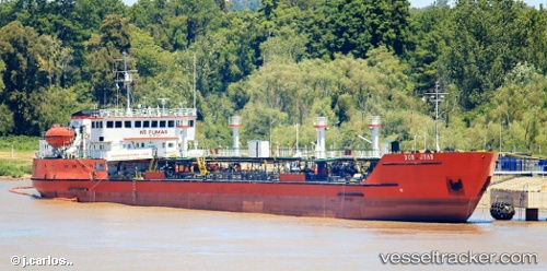
Don Juan
Current StatusWhere is the vessel?
Don Juan is currently in 11 nm NE of CIUDAD DE CORRIENTES, based on AIS data received about 14h ago.
Latest AIS update:
Current position: 27.36450° S, 58.67665° W (11 nm NE of CIUDAD DE CORRIENTES)
Average speed (last 7 days): Loading…
Average speed (last 30 days): Loading…
Vessel profile: Don Juan is a Oil Products Tanker with dimensions 15m x 122m.
This page combines live AIS, route history, probable destination signals, nearby traffic, and port activity for practical vessel monitoring.
The current position of vessel Don Juan is -27.36450 lat / -58.67665 lng. Updated: 2026-05-20 16:30:22 UTCNearest reference points:
- Near Asunción
- 88 nm N of Campo Largo
Details:
Live Vessel Don Juan Analytics (details, animations, etc.)
Recent AIS points (UTC):
2026-05-20 13:15:23 UTC · -27.05553, -58.51995 · SOG 8.5 kn · COG -1°2026-05-20 13:35:53 UTC · -27.03836, -58.56179 · SOG 10.3 kn · COG -1°
2026-05-20 15:47:20 UTC · -27.29993, -58.61667 · SOG 10.7 kn · COG -1°
2026-05-20 16:30:22 UTC · -27.36450, -58.67665 · SOG 6.6 kn · COG -1°