 ABIGAIL JOSEPH
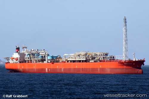
Current Status
Where is the vessel?
ABIGAIL JOSEPH is currently in 24 nm SE of Pennington Terminal, based on AIS data received about 14h ago.
Latest AIS update:
Current position: 3.93378° N, 5.86983° E (24 nm SE of Pennington Terminal)
Average speed (last 7 days): Loading…
Average speed (last 30 days): Loading…
Vessel profile: ABIGAIL JOSEPH is a Offshore Processing Ship with dimensions 44m x 274m.
This page combines live AIS, route history, probable destination signals, nearby traffic, and port activity for practical vessel monitoring.
The current position of vessel ABIGAIL JOSEPH is 3.93378 lat / 5.86983 lng. Updated: 2026-05-20 13:11:36 UTCNearest reference points:
- 12 nm N of Okwori
- 21 nm SW of Bonny
- Near Port Harcourt
Currently sailing under the flag of Marshall Islands ![]()
ABIGAIL JOSEPH built in 1992 year
Deadweight:
145242 tDetails:
Live Vessel ABIGAIL JOSEPH Analytics (details, animations, etc.)
Recent AIS points (UTC):
2026-05-20 10:11:29 UTC · 3.93376, 5.86985 · SOG 0.1 kn · COG 23°2026-05-20 10:11:29 UTC · 3.93376, 5.86985 · SOG 0.1 kn · COG 23°
2026-05-20 13:11:36 UTC · 3.93378, 5.86983 · SOG 0 kn · COG 23°
2026-05-20 13:11:36 UTC · 3.93378, 5.86983 · SOG 0 kn · COG 23°