 CNTIC VPOWER ENERGY
Current Status
Where is the vessel?
CNTIC VPOWER ENERGY is currently in Near Thilawa, based on AIS data received about 14h ago.
Latest AIS update:
Current position: 16.65288° N, 96.25997° E (Near Thilawa)
Average speed (last 7 days): Loading…
Average speed (last 30 days): Loading…
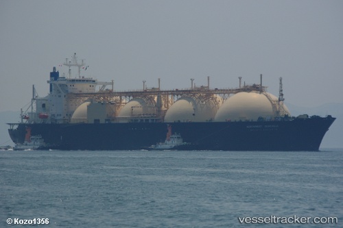
Vessel profile: CNTIC VPOWER ENERGY is a FSO, Gas with dimensions 47m x 272m.
This page combines live AIS, route history, probable destination signals, nearby traffic, and port activity for practical vessel monitoring.
The current position of vessel CNTIC VPOWER ENERGY is 16.65288 lat / 96.25997 lng. Updated: 2026-05-20 13:17:07 UTCNearest reference points:
- Near Thilawa
- 80 nm SW of Sangkhla Buri Customs House
Currently sailing under the flag of Liberia ![]()
CNTIC VPOWER ENERGY built in 1992 year
Deadweight:
67003 tDetails:
Live Vessel CNTIC VPOWER ENERGY Analytics (details, animations, etc.)
Recent AIS points (UTC):
2026-05-20 10:08:07 UTC · 16.65287, 96.25993 · SOG 0 kn · COG 142°2026-05-20 10:38:12 UTC · 16.65288, 96.25995 · SOG 0 kn · COG 142°
2026-05-20 11:29:07 UTC · 16.65287, 96.25993 · SOG 0 kn · COG 142°
2026-05-20 13:17:07 UTC · 16.65288, 96.25997 · SOG 0 kn · COG 141°