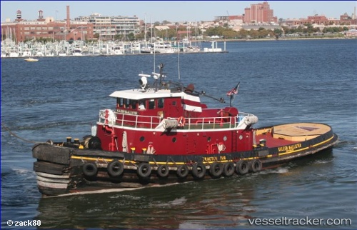
 KALEEN MCALLISTER
Current Status
Where is the vessel?
KALEEN MCALLISTER is currently in Near Blount Island, based on AIS data received about 14h ago.
Latest AIS update:
Current position: 30.39780° N, 81.55201° W (Near Blount Island)
Average speed (last 7 days): Loading…
Average speed (last 30 days): Loading…
Vessel profile: KALEEN MCALLISTER is a Tug with dimensions m x m.
This page combines live AIS, route history, probable destination signals, nearby traffic, and port activity for practical vessel monitoring.
The current position of vessel KALEEN MCALLISTER is 30.39780 lat / -81.55201 lng. Updated: 2026-06-22 13:49:08 UTCNearest reference points:
- Near Jacksonville
- Near Fernandina
- Near Ponte Vedra
Currently sailing under the flag of United States ![]()
Details:
Live Vessel KALEEN MCALLISTER Analytics (details, animations, etc.)
Recent AIS points (UTC):
2026-06-22 10:52:36 UTC · 30.39782, -81.55200 · SOG 0 kn · COG -1°2026-06-22 11:23:07 UTC · 30.39784, -81.55198 · SOG 0 kn · COG -1°
2026-06-22 13:09:37 UTC · 30.39780, -81.55199 · SOG 0 kn · COG -1°
2026-06-22 13:49:08 UTC · 30.39780, -81.55201 · SOG 0 kn · COG -1°