 ISLA TAUTIL
Current Status
Where is the vessel?
ISLA TAUTIL is currently in Near Puerto Montt, based on AIS data received about 14h ago.
Latest AIS update:
Current position: 41.50424° S, 72.99394° W (Near Puerto Montt)
Average speed (last 7 days): Loading…
Average speed (last 30 days): Loading…
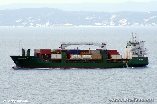
Vessel profile: ISLA TAUTIL is a General Cargo Ship with dimensions 13m x 83m.
This page combines live AIS, route history, probable destination signals, nearby traffic, and port activity for practical vessel monitoring.
The current position of vessel ISLA TAUTIL is -41.50424 lat / -72.99394 lng. Updated: 2026-05-19 13:56:39 UTCNearest reference points:
- Near Puerto Montt
- Near Chonchi
- Near Quellón (Puerto Quellón)
Currently sailing under the flag of Chile ![]()
ISLA TAUTIL built in 1991 year
Deadweight:
2750 tDetails:
Live Vessel ISLA TAUTIL Analytics (details, animations, etc.)
Recent AIS points (UTC):
2026-05-19 10:42:01 UTC · -41.67740, -73.02276 · SOG 6.7 kn · COG 350°2026-05-19 11:22:32 UTC · -41.59733, -73.03297 · SOG 9.9 kn · COG 355°
2026-05-19 13:41:59 UTC · -41.50578, -72.99349 · SOG 1.9 kn · COG 347°
2026-05-19 13:56:39 UTC · -41.50424, -72.99394 · SOG 0 kn · COG 317°