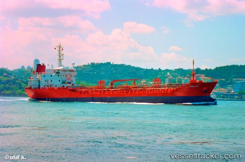
 Marmara
Current Status
Where is the vessel?
Marmara is currently in Near TUZLA, based on AIS data received about 14h ago.
Latest AIS update:
Current position: 40.84218° N, 29.27312° E (Near TUZLA)
Average speed (last 7 days): Loading…
Average speed (last 30 days): Loading…
Vessel profile: Marmara is a Chemical Oil Products Tanker with dimensions 97m x 16m.
This page combines live AIS, route history, probable destination signals, nearby traffic, and port activity for practical vessel monitoring.
The current position of vessel Marmara is 40.84218 lat / 29.27312 lng. Updated: 2026-06-29 16:24:15 UTCNearest reference points:
- Near TUZLA
- Near PENDIK
- Near Tuzla Free Zone
Currently sailing under the flag of Malta ![]()
Marmara built in 1996 year
Deadweight:
4994 tDetails:
Live Vessel Marmara Analytics (details, animations, etc.)
Recent AIS points (UTC):
2026-06-29 11:39:15 UTC · 40.84222, 29.27314 · SOG 0 kn · COG 242°2026-06-29 13:09:28 UTC · 40.84217, 29.27313 · SOG 0 kn · COG -1°
2026-06-29 13:36:15 UTC · 40.84216, 29.27314 · SOG 0 kn · COG 242°
2026-06-29 16:24:15 UTC · 40.84218, 29.27312 · SOG 0 kn · COG 242°