 vesseltracker.com
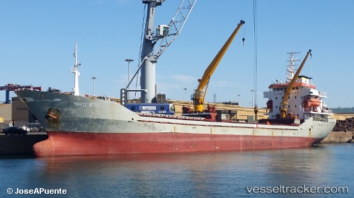
 POYRAZ DEMIR
Current Status
Where is the vessel?
POYRAZ DEMIR is currently in Near Rize, based on AIS data received about 4h ago.
Latest AIS update:
Current position: 41.03623° N, 40.51351° E (Near Rize)
Average speed (last 7 days): Loading…
Average speed (last 30 days): Loading…
Vessel profile: POYRAZ DEMIR is a General Cargo Ship with dimensions 14m x 96m.
This page combines live AIS, route history, probable destination signals, nearby traffic, and port activity for practical vessel monitoring.
The current position of vessel POYRAZ DEMIR is 41.03623 lat / 40.51351 lng. Updated: 2026-05-14 17:04:47 UTCNearest reference points:
- Near Rize
- 31 nm N of Pazar
- Near Hopa
Currently sailing under the flag of Turkey ![]()
POYRAZ DEMIR built in 1992 year
Deadweight:
4592 tDetails:
Live Vessel POYRAZ DEMIR Analytics (details, animations, etc.)
Recent AIS points (UTC):
2026-05-14 16:26:35 UTC · 41.05715, 40.50590 · SOG 7.5 kn · COG 106°2026-05-14 17:04:47 UTC · 41.03623, 40.51351 · SOG 1.2 kn · COG 5°
2026-05-14 17:04:47 UTC · 41.03623, 40.51351 · SOG 1.2 kn · COG 5°
2026-05-14 17:04:47 UTC · 41.03623, 40.51351 · SOG 1.2 kn · COG 5°