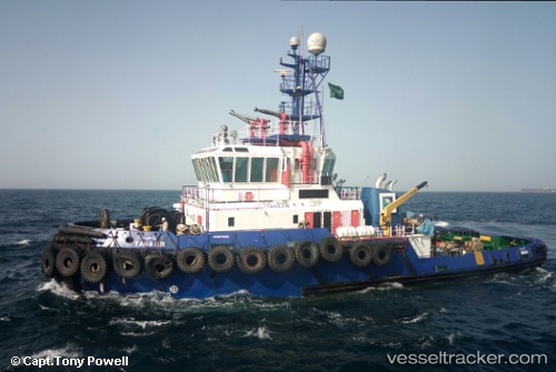
M.v.tanajib
Current StatusWhere is the vessel?
M.v.tanajib is currently in Near Ras Tannurah, based on AIS data received about 14h ago.
Latest AIS update:
Current position: 26.64343° N, 50.16870° E (Near Ras Tannurah)
Average speed (last 7 days): Loading…
Average speed (last 30 days): Loading…
Vessel profile: M.v.tanajib is a Tug with dimensions 13m x 41m.
This page combines live AIS, route history, probable destination signals, nearby traffic, and port activity for practical vessel monitoring.
The current position of vessel M.v.tanajib is 26.64343 lat / 50.16870 lng. Updated: 2026-05-18 23:41:43 UTCNearest reference points:
- Near DAMMAM
- Near Ad Dammam
- Near Sayhat
Details:
Live Vessel M.v.tanajib Analytics (details, animations, etc.)
Recent AIS points (UTC):
2026-05-18 19:38:24 UTC · 26.64427, 50.16719 · SOG 0 kn · COG -1°2026-05-18 21:59:44 UTC · 26.64342, 50.16867 · SOG 0 kn · COG 340°
2026-05-18 22:30:06 UTC · 26.64341, 50.16864 · SOG 0 kn · COG -1°
2026-05-18 23:41:43 UTC · 26.64343, 50.16870 · SOG 0 kn · COG 326°