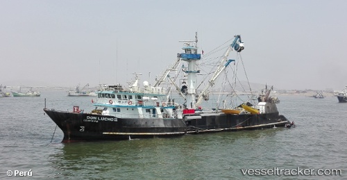
Don Juan
Current StatusWhere is the vessel?
Don Juan is currently in Near Oquendo, based on AIS data received about 14h ago.
Latest AIS update:
Current position: 12.00688° S, 77.15330° W (Near Oquendo)
Average speed (last 7 days): Loading…
Average speed (last 30 days): Loading…
Vessel profile: Don Juan is a Fishing Vessel with dimensions 11m x 61m.
This page combines live AIS, route history, probable destination signals, nearby traffic, and port activity for practical vessel monitoring.
The current position of vessel Don Juan is -12.00688 lat / -77.15330 lng. Updated: 2026-05-22 12:04:41 UTCNearest reference points:
- Near Callao
- 43 nm SW of Barranca
- 125 nm SW of Supe Bay
Details:
Live Vessel Don Juan Analytics (details, animations, etc.)
Recent AIS points (UTC):
2026-05-22 07:54:22 UTC · -12.00688, -77.15336 · SOG 0.1 kn · COG 172°2026-05-22 09:59:11 UTC · -12.00687, -77.15335 · SOG 0.1 kn · COG 186°
2026-05-22 10:18:22 UTC · -12.00689, -77.15337 · SOG 0.1 kn · COG 161°
2026-05-22 12:04:41 UTC · -12.00688, -77.15330 · SOG 0.1 kn · COG 165°