 vesseltracker.com
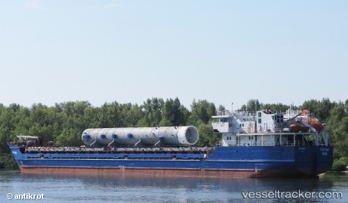
 Habibe Ana
Current Status
Where is the vessel?
Habibe Ana is currently in 16 nm SE of Moúdhros, based on AIS data received about 4h ago.
Latest AIS update:
Current position: 39.70414° N, 25.54623° E (16 nm SE of Moúdhros)
Average speed (last 7 days): Loading…
Average speed (last 30 days): Loading…
Vessel profile: Habibe Ana is a General Cargo Ship with dimensions 96m x 14m.
This page combines live AIS, route history, probable destination signals, nearby traffic, and port activity for practical vessel monitoring.
The current position of vessel Habibe Ana is 39.70414 lat / 25.54623 lng. Updated: 2026-05-02 11:24:24 UTCNearest reference points:
- 14 nm SW of Bozcaada
- 14 nm NW of Baba Point
- 16 nm NW of Sigri Lesvou
Currently sailing under the flag of Panama ![]()
Habibe Ana built in 1995 year
Deadweight:
3837 tDetails:
Live Vessel Habibe Ana Analytics (details, animations, etc.)
Recent AIS points (UTC):
2026-05-02 11:24:24 UTC · 39.70414, 25.54623 · SOG 7.2 kn · COG 194°2026-05-02 11:24:24 UTC · 39.70414, 25.54623 · SOG 7.2 kn · COG 194°
2026-05-02 11:24:24 UTC · 39.70414, 25.54623 · SOG 7.2 kn · COG 194°
2026-05-02 11:24:24 UTC · 39.70414, 25.54623 · SOG 7.2 kn · COG 194°