 vesseltracker.com
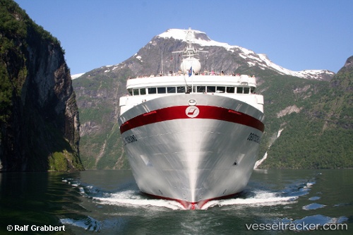
 Deutschland
Current Status
Where is the vessel?
Deutschland is currently in Near Aberdeen, based on AIS data received less than 1h ago.
Latest AIS update:
Current position: 57.13445° N, 2.05852° W (Near Aberdeen)
Average speed (last 7 days): Loading…
Average speed (last 30 days): Loading…
Vessel profile: Deutschland is a Cruise Ship with dimensions 175m x 23m.
This page combines live AIS, route history, probable destination signals, nearby traffic, and port activity for practical vessel monitoring.
The current position of vessel Deutschland is 57.13445 lat / -2.05852 lng. Updated: 2026-05-15 08:12:29 UTCNearest reference points:
- Near Aberdeen
- Near PETERHEAD
- Near Peterhead
Currently sailing under the flag of Bahamas ![]()
Deutschland built in 1998 year
Deadweight:
3460 tDetails:
Live Vessel Deutschland Analytics (details, animations, etc.)
Recent AIS points (UTC):
2026-05-15 05:07:38 UTC · 56.97618, -2.01630 · SOG 11.2 kn · COG 1°2026-05-15 05:58:50 UTC · 57.13893, -2.01615 · SOG 6 kn · COG 260°
2026-05-15 07:32:09 UTC · 57.13447, -2.05853 · SOG 0 kn · COG 0°
2026-05-15 08:12:29 UTC · 57.13445, -2.05852 · SOG 0 kn · COG 0°