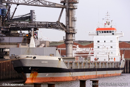
 Arne
Arne
Current Status
Where is the vessel?
Arne is currently in Near Sopot, based on AIS data received about 14h ago.
Latest AIS update:
Current position: 54.46372° N, 18.64446° E (Near Sopot)
Average speed (last 7 days): Loading…
Average speed (last 30 days): Loading…
Vessel profile: Arne is a General Cargo Ship with dimensions 134m x 16m.
This page combines live AIS, route history, probable destination signals, nearby traffic, and port activity for practical vessel monitoring.
The current position of vessel Arne is 54.46372 lat / 18.64446 lng. Updated: 2026-05-19 21:39:12 UTCNearest reference points:
- Near Sopot
- Near Nowy Port/Gdansk
- Near Gdynia
Currently sailing under the flag of Antigua Barbuda ![]()
Arne built in 1998 year
Deadweight:
9150 tDetails:
Live Vessel Arne Analytics (details, animations, etc.)
Recent AIS points (UTC):
2026-05-19 17:21:10 UTC · 54.46294, 18.64591 · SOG 0.1 kn · COG 17°2026-05-19 19:27:12 UTC · 54.46304, 18.64578 · SOG 0 kn · COG 24°
2026-05-19 19:30:55 UTC · 54.46302, 18.64579 · SOG 0 kn · COG -1°
2026-05-19 21:39:12 UTC · 54.46372, 18.64446 · SOG 0.1 kn · COG 68°