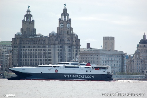
 Manannan
Current Status
Where is the vessel?
Manannan is currently in Near Liverpool, based on AIS data received about 14h ago.
Latest AIS update:
Current position: 53.42277° N, 3.01120° W (Near Liverpool)
Average speed (last 7 days): Loading…
Average speed (last 30 days): Loading…
Vessel profile: Manannan is a Passenger Ro Ro Cargo Ship with dimensions 96m x 26m.
This page combines live AIS, route history, probable destination signals, nearby traffic, and port activity for practical vessel monitoring.
The current position of vessel Manannan is 53.42277 lat / -3.01120 lng. Updated: 2026-05-20 16:04:45 UTCNearest reference points:
- Near BIRKENHEAD
- Near ELLESMERE
- Near LIVERPOOL ANCH
Currently sailing under the flag of United Kingdom ![]()
Manannan built in 1998 year
Deadweight:
800 tDetails:
Live Vessel Manannan Analytics (details, animations, etc.)
Recent AIS points (UTC):
2026-05-20 09:56:37 UTC · 54.86975, -5.74437 · SOG 29.9 kn · COG 102°2026-05-20 13:21:59 UTC · 54.14778, -4.47108 · SOG 0 kn · COG 108°
2026-05-20 13:36:58 UTC · 54.14778, -4.47108 · SOG 0 kn · COG 108°
2026-05-20 16:04:45 UTC · 53.42277, -3.01120 · SOG 12 kn · COG 161°