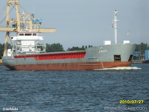
 Drait
Drait
Current Status
Where is the vessel?
Drait is currently in 29 nm NW of Villy-le-Moutier, based on AIS data received about 14h ago.
Latest AIS update:
Current position: 47.65398° N, 5.53848° W (29 nm NW of Villy-le-Moutier)
Average speed (last 7 days): Loading…
Average speed (last 30 days): Loading…
Vessel profile: Drait is a General Cargo Ship with dimensions 89m x 12m.
This page combines live AIS, route history, probable destination signals, nearby traffic, and port activity for practical vessel monitoring.
The current position of vessel Drait is 47.65398 lat / -5.53848 lng. Updated: 2026-06-11 10:18:13 UTCNearest reference points:
- 14 nm W of Villy-le-Moutier
- 46 nm W of SEIN
- 10 nm S of MOLENE
Currently sailing under the flag of Netherlands ![]()
Drait built in 2000 year
Deadweight:
3650 tDetails:
Live Vessel Drait Analytics (details, animations, etc.)
Recent AIS points (UTC):
2026-06-11 07:22:49 UTC · 47.27349, -5.40107 · SOG 8.1 kn · COG 340°2026-06-11 07:51:52 UTC · 47.33501, -5.43000 · SOG 7.6 kn · COG 339°
2026-06-11 10:10:13 UTC · 47.63681, -5.53367 · SOG 7.9 kn · COG 339°
2026-06-11 10:18:13 UTC · 47.65398, -5.53848 · SOG 8 kn · COG 341°