 vesseltracker.com
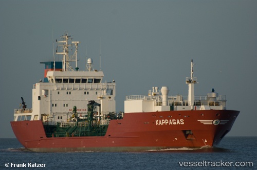
 Kappagas
Current Status
Where is the vessel?
Kappagas is currently in 19 nm NW of Villanueva de Lorenzana, based on AIS data received about 14h ago.
Latest AIS update:
Current position: 43.62667° N, 9.65833° W (19 nm NW of Villanueva de Lorenzana)
Average speed (last 7 days): Loading…
Average speed (last 30 days): Loading…
Vessel profile: Kappagas is a Lpg Tanker with dimensions 108m x 18m.
This page combines live AIS, route history, probable destination signals, nearby traffic, and port activity for practical vessel monitoring.
The current position of vessel Kappagas is 43.62667 lat / -9.65833 lng. Updated: 2026-05-18 01:23:39 UTCNearest reference points:
- 13 nm NE of Villanueva de Lorenzana
- 30 nm NW of Meiras-Valdoviño
- Near Portosin
Currently sailing under the flag of Antigua Barbuda ![]()
Kappagas built in 2001 year
Deadweight:
6211 tDetails:
Live Vessel Kappagas Analytics (details, animations, etc.)
Recent AIS points (UTC):
2026-05-17 22:20:45 UTC · 43.08938, -9.95195 · SOG 11.3 kn · COG 0°2026-05-17 23:30:16 UTC · 43.30177, -9.89688 · SOG 11.8 kn · COG 24°
2026-05-18 01:23:39 UTC · 43.62667, -9.65833 · SOG 12 kn · COG -1°
2026-05-18 01:23:39 UTC · 43.62667, -9.65833 · SOG 12 kn · COG -1°