 MAURITIUS TROCHETIA
Current Status
Where is the vessel?
MAURITIUS TROCHETIA is currently in 218 nm N of Pereybèré, based on AIS data received about 14h ago.
Latest AIS update:
Current position: 16.37833° S, 57.10500° E (218 nm N of Pereybèré)
Average speed (last 7 days): Loading…
Average speed (last 30 days): Loading…
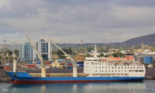
Vessel profile: MAURITIUS TROCHETIA is a Passenger/Cargo Ship with dimensions 108m x 18m.
This page combines live AIS, route history, probable destination signals, nearby traffic, and port activity for practical vessel monitoring.
The current position of vessel MAURITIUS TROCHETIA is -16.37833 lat / 57.10500 lng. Updated: 2026-07-08 04:54:51 UTCNearest reference points:
- 164 nm NW of Pointe aux Canonniers
Currently sailing under the flag of Mauritius ![]()
MAURITIUS TROCHETIA built in 2001 year
Deadweight:
3500 tDetails:
Live Vessel MAURITIUS TROCHETIA Analytics (details, animations, etc.)
Recent AIS points (UTC):
2026-07-08 01:08:11 UTC · -17.16039, 57.17778 · SOG 13.5 kn · COG 357°2026-07-08 02:56:59 UTC · -16.78008, 57.14243 · SOG 11.9 kn · COG 356°
2026-07-08 03:54:54 UTC · -16.57833, 57.13333 · SOG 12 kn · COG -1°
2026-07-08 04:54:51 UTC · -16.37833, 57.10500 · SOG 11 kn · COG -1°