 vesseltracker.com
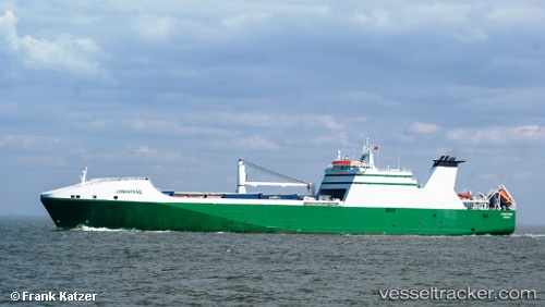
 NEW AMSTERDAM
Current Status
Where is the vessel?
NEW AMSTERDAM is currently in Near Town Quays/Drogheda, based on AIS data received about 1h ago.
Latest AIS update:
Current position: 53.63453° N, 6.20850° E (Near Town Quays/Drogheda)
Average speed (last 7 days): Loading…
Average speed (last 30 days): Loading…
Vessel profile: NEW AMSTERDAM is a Ro-Ro Cargo Ship with dimensions 193m x 26m.
This page combines live AIS, route history, probable destination signals, nearby traffic, and port activity for practical vessel monitoring.
The current position of vessel NEW AMSTERDAM is 53.63453 lat / 6.20850 lng. Updated: 2026-05-01 06:22:22 UTCNearest reference points:
- 14 nm NW of Town Quays/Drogheda
- Near Hoogkerk
- Near Borkum
Currently sailing under the flag of Netherlands ![]()
NEW AMSTERDAM built in 2003 year
Deadweight:
13274 tDetails:
Live Vessel NEW AMSTERDAM Analytics (details, animations, etc.)
Recent AIS points (UTC):
2026-05-01 02:33:22 UTC · 53.63328, 6.20533 · SOG 0 kn · COG 102°2026-05-01 03:42:22 UTC · 53.63343, 6.20538 · SOG 0.2 kn · COG 104°
2026-05-01 04:09:24 UTC · 53.63365, 6.20552 · SOG 0 kn · COG 111°
2026-05-01 06:22:22 UTC · 53.63453, 6.20850 · SOG 0 kn · COG 199°