 vesseltracker.com
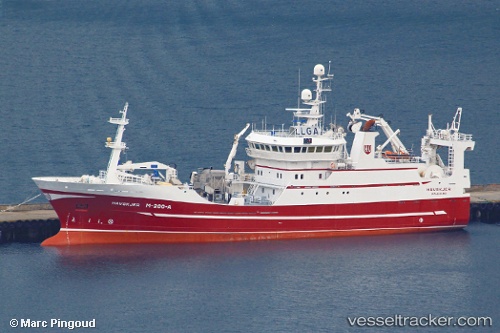
 BIRITA
Current Status
Where is the vessel?
BIRITA is currently in Near FUGLAFJORDUR, based on AIS data received about 16h ago.
Latest AIS update:
Current position: 62.23733° N, 6.80222° W (Near FUGLAFJORDUR)
Average speed (last 7 days): Loading…
Average speed (last 30 days): Loading…
Vessel profile: BIRITA is a Fishing Vessel with dimensions 60m x 13m.
This page combines live AIS, route history, probable destination signals, nearby traffic, and port activity for practical vessel monitoring.
The current position of vessel BIRITA is 62.23733 lat / -6.80222 lng. Updated: 2026-05-18 11:23:53 UTCNearest reference points:
- Near FUGLAFJORDUR
- Near VESTMANNA
- 20 nm S of Vágur
Currently sailing under the flag of Faroe Islands ![]()
BIRITA built in 2000 year
Deadweight:
0 tDetails:
Live Vessel BIRITA Analytics (details, animations, etc.)
Recent AIS points (UTC):
2026-05-18 08:20:22 UTC · 62.23738, -6.80221 · SOG 0 kn · COG 324°2026-05-18 09:43:33 UTC · 62.23742, -6.80219 · SOG 0 kn · COG 323°
2026-05-18 10:08:43 UTC · 62.23736, -6.80236 · SOG 0 kn · COG 322°
2026-05-18 11:23:53 UTC · 62.23733, -6.80222 · SOG 0 kn · COG 324°