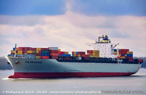
 Folegandros
Current Status
Where is the vessel?
Folegandros is currently in 12 nm S of Maji Shan, based on AIS data received about 14h ago.
Latest AIS update:
Current position: 30.48827° N, 122.48353° E (12 nm S of Maji Shan)
Average speed (last 7 days): Loading…
Average speed (last 30 days): Loading…
Vessel profile: Folegandros is a Container Ship with dimensions 279m x 279m.
This page combines live AIS, route history, probable destination signals, nearby traffic, and port activity for practical vessel monitoring.
The current position of vessel Folegandros is 30.48827 lat / 122.48353 lng. Updated: 2026-05-25 14:16:49 UTCNearest reference points:
- 14 nm NE of JINHAI HEAVY INDUSTR
- 10 nm NE of JINHAI HEAVY INDUSTR
- 11 nm N of JINHAI HEAVY INDUSTR
Currently sailing under the flag of Liberia ![]()
Folegandros built in 2001 year
Deadweight:
67170 tDetails:
Live Vessel Folegandros Analytics (details, animations, etc.)
Recent AIS points (UTC):
2026-05-25 10:08:00 UTC · 30.49042, 122.47703 · SOG 0 kn · COG 105°2026-05-25 12:16:47 UTC · 30.49033, 122.48255 · SOG 0.1 kn · COG 249°
2026-05-25 14:02:14 UTC · 30.48865, 122.48380 · SOG 0.2 kn · COG 284°
2026-05-25 14:16:49 UTC · 30.48827, 122.48353 · SOG 0.1 kn · COG 290°