 REUS
REUS
Current Status
Where is the vessel?
REUS is currently in 10 nm W of Sosnovyy Bor, based on AIS data received about 14h ago.
Latest AIS update:
Current position: 59.94597° N, 28.77261° E (10 nm W of Sosnovyy Bor)
Average speed (last 7 days): Loading…
Average speed (last 30 days): Loading…
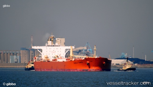
Vessel profile: REUS is a Crude Oil Tanker with dimensions 247m x 42m.
This page combines live AIS, route history, probable destination signals, nearby traffic, and port activity for practical vessel monitoring.
The current position of vessel REUS is 59.94597 lat / 28.77261 lng. Updated: 2026-07-15 08:11:24 UTCNearest reference points:
- 10 nm NE of VISTINO
- Near VISTINO
- 11 nm NE of VISTINO
Currently sailing under the flag of Sierra Leone ![]()
REUS built in 2003 year
Deadweight:
107123 tDetails:
Live Vessel REUS Analytics (details, animations, etc.)
Recent AIS points (UTC):
2026-07-14 16:01:26 UTC · 59.94861, 28.74873 · SOG 0.4 kn · COG 345°2026-07-14 16:01:26 UTC · 59.94861, 28.74873 · SOG 0.4 kn · COG 345°
2026-07-15 07:30:33 UTC · 59.95029, 28.76738 · SOG 0.5 kn · COG 192°
2026-07-15 08:11:24 UTC · 59.94597, 28.77261 · SOG 0.5 kn · COG 188°