.
Vessel photo of ANSHUN II (IMO 9253117) vesseltracker.com

PA flag ANSHUN II

Vessel type: Crude Oil Tanker | IMO: 9253117 | MMSI: MMSI: 356569000
Call sign: 3FWU9 | Dimensions: 332 m x 58 m
Current Status

Where is the vessel?

ANSHUN II is currently in 71 nm NE of Kampung Tanjung Langsat, based on AIS data received about 1h ago.

Latest AIS update:

Current position: 2.35933° N, 104.80278° E (71 nm NE of Kampung Tanjung Langsat)

Average speed (last 7 days): Loading…

Average speed (last 30 days): Loading…

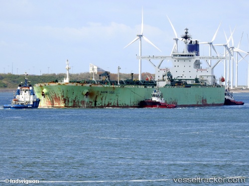
Vessel profile: ANSHUN II is a Crude Oil Tanker with dimensions 332m x 58m.

This page combines live AIS, route history, probable destination signals, nearby traffic, and port activity for practical vessel monitoring.

The current position of vessel ANSHUN II is 2.35933 lat / 104.80278 lng. Updated: 2026-04-21 10:20:16 UTC
Nearest reference points:
  • 64 nm NE of PENGERANG
  • 80 nm SW of Terempa
  • 53 nm NE of PENGERANG

Currently sailing under the flag of Panama PA flag

ANSHUN II built in 2003 year

Deadweight:
298717 t

Details:

Live Vessel ANSHUN II Analytics (details, animations, etc.)


Recent AIS points (UTC):
2026-04-21 05:25:40 UTC · 2.35933, 104.80278 · SOG 0.2 kn · COG -1°
2026-04-21 06:56:40 UTC · 2.35933, 104.80278 · SOG 0.2 kn · COG -1°
2026-04-21 08:13:32 UTC · 2.35933, 104.80278 · SOG 0.1 kn · COG 119°
2026-04-21 10:20:16 UTC · 2.35933, 104.80278 · SOG 0.1 kn · COG 119°

Track of the vessel in the last 60 days


UTC: --
Start: -- Track timeline (UTC) End: --
Encountered: --


Link to the map:


Find another ship

ANSHUN_II (356569000) last ports (portcalls and passsages)

Changi | 2025-09-14 11:41:22
JURONG ISLAND | 2025-08-30 23:54:14
PULAU SAMBU | 2025-08-30 22:28:05
BATU AMPAR | 2025-08-30 21:38:53
TANAH MERAH | 2025-08-30 21:23:26
PENGERANG | 2025-08-30 20:12:30
PENGERANG | 2025-08-08 07:54:32
TANAH MERAH | 2025-08-08 07:13:19
JURONG ISLAND | 2025-08-03 05:53:10
PULAU SAMBU | 2025-08-03 04:16:00
BATU AMPAR | 2025-08-03 02:43:56
TANAH MERAH | 2025-08-01 05:15:00
PENGERANG | 2025-08-01 03:05:57
PULAU SAMBU | 2025-07-26 09:36:30
BUKOM ISLAND | 2025-07-25 13:06:32
JURONG ISLAND | 2025-07-25 12:15:50
BATU AMPAR | 2025-07-25 08:41:14
TANAH MERAH | 2025-07-25 08:19:57
PENGERANG | 2025-07-25 07:19:29
PENGERANG | 2025-07-02 00:55:34
TANAH MERAH | 2025-07-01 06:11:13
Singapore | 2025-07-01 04:32:06
PULAU SAMBU | 2025-07-01 04:12:13
PULAU SAMBU | 2025-06-24 22:49:59
TANAH MERAH | 2025-06-24 03:02:42
PENGERANG | 2025-06-24 00:47:40
ZHOUSHAN | 2025-06-07 00:30:52
ZHOUSHAN | 2025-06-03 00:02:14
BATU AMPAR | 2025-05-09 00:36:57
TANAH MERAH | 2025-05-08 09:06:45
PENGERANG | 2025-05-08 07:40:58
LANSHAN | 2025-04-20 02:16:00
TANAH MERAH | 2025-04-05 00:49:37
PENGERANG | 2025-04-04 22:18:27
Taku Bar | 2025-03-25 01:31:39
Ta-Ku | 2025-03-24 10:38:09
Ta-Ku | 2025-03-20 09:47:15
Taku Bar | 2025-03-20 07:22:41
PENGERANG | 2025-03-01 07:08:06
TANAH MERAH | 2025-03-01 06:01:49
PULAU SAMBU | 2025-03-01 04:57:13
Singapore | 2024-08-23 09:36:54
Singapore | 2024-07-29 09:24:29
Malacca | 2024-07-24 13:49:11
Sambu | 2024-07-23 05:47:31
Willemstad | 2024-04-04 20:43:28
Oranjestad | 2024-03-29 10:37:33
Barcelona | 2024-01-15 09:35:37
Barcelona | 2024-01-11 09:19:28
Sambu | 2023-11-03 23:24:53
Strait Of Gibraltar | 2023-03-20 20:20:40
Port Said | 2023-02-13 17:11:03