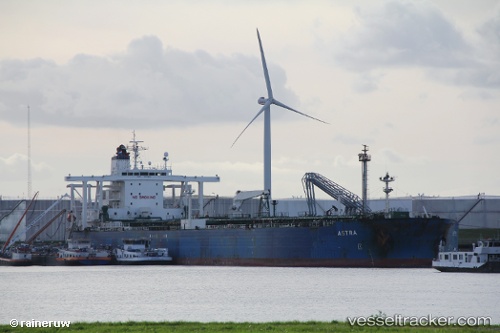
.
Vessel photo of JAMES II (IMO 9253909) vesseltracker.com

PW flag JAMES II

Vessel type: Crude Oil Tanker | IMO: 9253909 | MMSI: MMSI: 511100897
Call sign: T8A4118 | Dimensions: 45 m x 271 m
Current Status

Where is the vessel?

JAMES II is currently in 39 nm N of SILE, based on AIS data received about 14h ago.

Latest AIS update:

Current position: 41.81667° N, 29.70333° E (39 nm N of SILE)

Average speed (last 7 days): Loading…

Average speed (last 30 days): Loading…

Vessel profile: JAMES II is a Crude Oil Tanker with dimensions 45m x 271m.

This page combines live AIS, route history, probable destination signals, nearby traffic, and port activity for practical vessel monitoring.

The current position of vessel JAMES II is 41.81667 lat / 29.70333 lng. Updated: 2026-05-17 21:58:11 UTC
More recent position available: 21 min ago

Shipinfo shows free vessel positions with a delay. After payment, you will be able to view the current position of this vessel for 24 hours.

We recommend registering. If you register, paid vessel access will be saved in your profile. Guest access works only through a personal link.

Nearest reference points:
  • 45 nm N of RUMELI FENERI
  • 19 nm NE of RUMELI FENERI
  • Near RUMELI FENERI

Currently sailing under the flag of Palau PW flag

JAMES II built in 2002 year

Deadweight:
149995 t

Details:

Live Vessel JAMES II Analytics (details, animations, etc.)


Recent AIS points (UTC):
2026-05-17 19:16:12 UTC · 41.79616, 29.61804 · SOG 1.3 kn · COG 7°
2026-05-17 20:55:05 UTC · 41.80833, 29.66500 · SOG 2 kn · COG -1°
2026-05-17 21:58:11 UTC · 41.81667, 29.70333 · SOG 2 kn · COG -1°

Track of the vessel in the last 60 days


UTC: --
Start: -- Track timeline (UTC) End: --
Encountered: --


Link to the map:


Find another ship

JAMES_II (511100897) last ports (portcalls and passsages)

Willemstad | 2025-07-21 22:32:40
Strait Of Gibraltar | 2025-06-22 18:45:32
TARIFA | 2025-06-22 17:26:57
Port Said | 2025-06-15 15:20:53
ISMAILIA | 2025-06-15 11:34:21
SUEZ CANAL | 2025-06-15 09:26:30
SUEZ PORT | 2025-06-15 06:06:10
Jeddah | 2025-06-10 10:02:41
RAS SHUKHEIR | 2025-05-17 01:32:59
Ras Gharib | 2025-05-17 00:13:29
Ayn Sukhnah | 2025-05-16 17:26:18
AL ADABIYAH | 2025-05-16 15:26:07
SUEZ PORT | 2025-05-16 14:45:47
SUEZ CANAL | 2025-05-16 11:37:20
ISMAILIA | 2025-05-16 09:37:15
Port Said | 2025-05-16 04:53:10
TANGER MED | 2025-05-06 12:39:44
Strait Of Gibraltar | 2025-05-06 11:26:04
Primorsk | 2025-04-24 05:21:06
SPODSBJERG | 2025-04-18 10:42:57
Skagens Odde | 2025-04-17 16:44:41
Strait Of Gibraltar | 2025-04-11 19:00:01
BUGIBBA | 2025-04-08 06:27:03
MGARR | 2025-04-08 04:22:10
CIRKEWWA | 2025-04-07 19:00:11
Marsaxlokk | 2025-04-07 16:01:55
Port Said | 2025-04-04 15:21:24
ISMAILIA | 2025-04-04 10:54:46
SUEZ PORT | 2025-04-04 05:45:23
AL ADABIYAH | 2025-04-04 05:16:50
RAS SHUKHEIR | 2025-04-02 04:43:35
RAS SHUKHEIR | 2025-03-09 04:06:08
AL ADABIYAH | 2025-03-08 17:06:48
ISMAILIA | 2025-03-08 10:59:02
Port Said | 2025-03-08 06:16:29
Gelibolu | 2025-03-04 06:24:24
Ambarli | 2025-02-28 09:15:45
BAKIRKOY | 2025-02-28 07:14:08
RUMELI FENERI | 2025-02-28 04:01:00
RUMELI FENERI | 2024-12-21 07:25:29
BOSTANCI | 2024-12-21 05:10:17
BAKIRKOY | 2024-12-21 04:19:11
BAKIRKOY | 2024-12-15 20:17:00
Gelibolu | 2024-12-15 10:54:12
Canakkale | 2024-12-15 09:22:30
Port Said | 2024-12-05 17:48:01
ISMAILIA | 2024-12-05 13:25:49
SUEZ CANAL | 2024-12-05 11:00:28
SUEZ PORT | 2024-12-05 07:53:28
AL ADABIYAH | 2024-12-04 22:39:20
Ras as Sidr | 2024-12-04 03:03:19
BUKOM ISLAND | 2024-11-17 00:36:51
PENGERANG | 2024-11-15 14:10:24
TANAH MERAH | 2024-11-14 08:09:56
BATU AMPAR | 2024-11-14 07:28:18
TANJUNG PELEPAS | 2024-11-04 03:59:49
TANJUNG PELEPAS | 2024-10-31 03:21:45
TANJUNG PELEPAS | 2024-10-27 02:36:24
TANJUNG PELEPAS | 2024-10-23 02:04:36
Singapore | 2024-10-20 23:54:49
Panama | 2023-01-07 14:02:12
Panama | 2023-01-03 11:54:24
Ra’S Shukhayr | 2021-12-28 05:17:56
Fujairah | 2021-12-15 09:40:27