 Langsund
Current Status
Where is the vessel?
Langsund is currently in Near Harøysundet, based on AIS data received about 14h ago.
Latest AIS update:
Current position: 62.88515° N, 6.90911° E (Near Harøysundet)
Average speed (last 7 days): Loading…
Average speed (last 30 days): Loading…
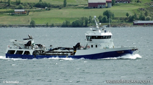
Vessel profile: Langsund is a Fish Carrier with dimensions 58m x 10m.
This page combines live AIS, route history, probable destination signals, nearby traffic, and port activity for practical vessel monitoring.
The current position of vessel Langsund is 62.88515 lat / 6.90911 lng. Updated: 2026-05-20 02:05:28 UTCNearest reference points:
- Near Aukra
- Near ELNESVAGEN
- Near Brattvåg
Currently sailing under the flag of Norway ![]()
Langsund built in 2001 year
Deadweight:
650 tDetails:
Live Vessel Langsund Analytics (details, animations, etc.)
Recent AIS points (UTC):
2026-05-19 22:48:26 UTC · 63.14717, 7.65796 · SOG 9.1 kn · COG 234°2026-05-20 00:01:26 UTC · 63.05409, 7.31646 · SOG 9 kn · COG 268°
2026-05-20 01:06:27 UTC · 62.99718, 6.97207 · SOG 9.1 kn · COG 246°
2026-05-20 02:05:28 UTC · 62.88515, 6.90911 · SOG 8.9 kn · COG 138°