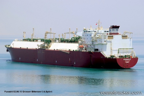
 Fuwairit
Current Status
Where is the vessel?
Fuwairit is currently in Near Mundra, based on AIS data received about 15h ago.
Latest AIS update:
Current position: 22.64898° N, 69.59717° E (Near Mundra)
Average speed (last 7 days): Loading…
Average speed (last 30 days): Loading…
Vessel profile: Fuwairit is a Lng Tanker with dimensions 278m x 42m.
This page combines live AIS, route history, probable destination signals, nearby traffic, and port activity for practical vessel monitoring.
The current position of vessel Fuwairit is 22.64898 lat / 69.59717 lng. Updated: 2026-06-12 14:18:14 UTCNearest reference points:
- Near Mundra
- Near SIKKA
- Near Khambhaliya
Currently sailing under the flag of Bahamas ![]()
Fuwairit built in 2004 year
Deadweight:
74067 tDetails:
Live Vessel Fuwairit Analytics (details, animations, etc.)
Recent AIS points (UTC):
2026-06-12 11:10:12 UTC · 22.65019, 69.59593 · SOG 0.2 kn · COG 202°2026-06-12 11:42:04 UTC · 22.64927, 69.59691 · SOG 0 kn · COG 240°
2026-06-12 14:00:27 UTC · 22.64883, 69.59717 · SOG 0.6 kn · COG -1°
2026-06-12 14:18:14 UTC · 22.64898, 69.59717 · SOG 0.6 kn · COG 255°