 Torrens
Current Status
Where is the vessel?
Torrens is currently in 378 nm W of Henties Bay (Hentiesbaai), based on AIS data received about 14h ago.
Latest AIS update:
Current position: 21.84500° S, 7.49333° E (378 nm W of Henties Bay (Hentiesbaai))
Average speed (last 7 days): Loading…
Average speed (last 30 days): Loading…
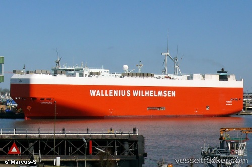
Vessel profile: Torrens is a Vehicles Carrier with dimensions 200m x 32m.
This page combines live AIS, route history, probable destination signals, nearby traffic, and port activity for practical vessel monitoring.
The current position of vessel Torrens is -21.84500 lat / 7.49333 lng. Updated: 2026-05-20 16:24:36 UTCNearest reference points:
- Open sea, approx. 410 nm off the nearest listed port
- Open sea, approx. 400 nm off the nearest listed port
- Open sea, approx. 405 nm off the nearest listed port
Currently sailing under the flag of Malta ![]()
Torrens built in 2004 year
Deadweight:
14512 tDetails:
Live Vessel Torrens Analytics (details, animations, etc.)
Recent AIS points (UTC):
2026-05-20 13:24:37 UTC · -22.49500, 8.01167 · SOG 16 kn · COG -1°2026-05-20 13:48:35 UTC · -22.39833, 7.95167 · SOG 16 kn · COG -1°
2026-05-20 16:19:08 UTC · -21.86600, 7.51009 · SOG 16.1 kn · COG 322°
2026-05-20 16:24:36 UTC · -21.84500, 7.49333 · SOG 15 kn · COG -1°