 vesseltracker.com
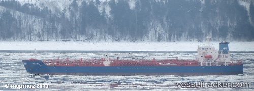
Marvea
Current StatusWhere is the vessel?
Marvea is currently in Open sea (no nearby ports in database), based on AIS data received about 1h ago.
Latest AIS update:
Current position: 15.75743° S, 2.52050° E (Open sea (no nearby ports in database))
Average speed (last 7 days): Loading…
Average speed (last 30 days): Loading…
Vessel profile: Marvea is a Chemical Oil Products Tanker with dimensions 31m x 176m.
This page combines live AIS, route history, probable destination signals, nearby traffic, and port activity for practical vessel monitoring.
The current position of vessel Marvea is -15.75743 lat / 2.52050 lng. Updated: 2026-05-17 16:14:49 UTCNearest reference points:
- Open sea (no nearby ports in database)
Details:
Live Vessel Marvea Analytics (details, animations, etc.)
Recent AIS points (UTC):
2026-05-17 13:24:51 UTC · -15.36123, 2.18302 · SOG 10.7 kn · COG 143°2026-05-17 13:44:39 UTC · -15.40718, 2.22213 · SOG 10.6 kn · COG 139°
2026-05-17 15:51:44 UTC · -15.70188, 2.47410 · SOG 11 kn · COG 139°
2026-05-17 16:14:49 UTC · -15.75743, 2.52050 · SOG 11 kn · COG 137°