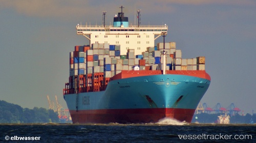
 Gudrun Maersk
Current Status
Where is the vessel?
Gudrun Maersk is currently in 38 nm S of Dokdo, based on AIS data received about 14h ago.
Latest AIS update:
Current position: 36.61931° N, 131.66788° E (38 nm S of Dokdo)
Average speed (last 7 days): Loading…
Average speed (last 30 days): Loading…
Vessel profile: Gudrun Maersk is a Container Ship with dimensions 368m x 42m.
This page combines live AIS, route history, probable destination signals, nearby traffic, and port activity for practical vessel monitoring.
The current position of vessel Gudrun Maersk is 36.61931 lat / 131.66788 lng. Updated: 2026-07-09 17:23:00 UTCNearest reference points:
- 67 nm W of NAKANOSHIMA
- 37 nm NW of NAKANOSHIMA
- 63 nm NW of Unnan
Currently sailing under the flag of Denmark ![]()
Gudrun Maersk built in 2005 year
Deadweight:
115700 tDetails:
Live Vessel Gudrun Maersk Analytics (details, animations, etc.)
Recent AIS points (UTC):
2026-07-09 05:45:50 UTC · 36.52244, 131.52940 · SOG 0.1 kn · COG 139°2026-07-09 07:42:31 UTC · 36.54031, 131.54488 · SOG 1.1 kn · COG 122°
2026-07-09 07:45:11 UTC · 36.54102, 131.54550 · SOG 1.1 kn · COG 122°
2026-07-09 17:23:00 UTC · 36.61931, 131.66788 · SOG 0.5 kn · COG 130°