 Xin Shan Tou
Current Status
Where is the vessel?
Xin Shan Tou is currently in Near Trebnje, based on AIS data received about 14h ago.
Latest AIS update:
Current position: 45.98667° N, 151.35667° E (Near Trebnje)
Average speed (last 7 days): Loading…
Average speed (last 30 days): Loading…
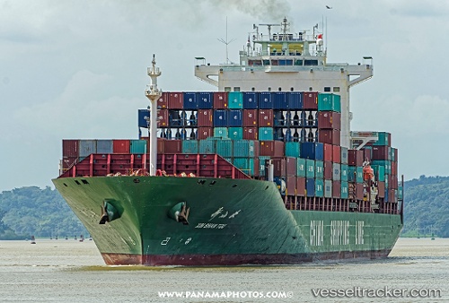
Vessel profile: Xin Shan Tou is a Container Ship with dimensions 263m x 32m.
This page combines live AIS, route history, probable destination signals, nearby traffic, and port activity for practical vessel monitoring.
The current position of vessel Xin Shan Tou is 45.98667 lat / 151.35667 lng. Updated: 2026-06-17 20:20:28 UTCCurrently sailing under the flag of China ![]()
Xin Shan Tou built in 2005 year
Deadweight:
52157 tDetails:
Live Vessel Xin Shan Tou Analytics (details, animations, etc.)
Recent AIS points (UTC):
2026-06-17 16:43:44 UTC · 46.53258, 152.37573 · SOG 15.5 kn · COG 234°2026-06-17 18:30:38 UTC · 46.26497, 151.86710 · SOG 14.4 kn · COG 231°
2026-06-17 19:42:17 UTC · 46.08017, 151.53653 · SOG 14.8 kn · COG 232°
2026-06-17 20:20:28 UTC · 45.98667, 151.35667 · SOG 14 kn · COG -1°