 Taipan
Current Status
Where is the vessel?
Taipan is currently in Open sea, approx. 411 nm off the nearest listed port, based on AIS data received about 14h ago.
Latest AIS update:
Current position: 39.88446° N, 166.34000° E (Open sea, approx. 411 nm off the nearest listed port)
Average speed (last 7 days): Loading…
Average speed (last 30 days): Loading…
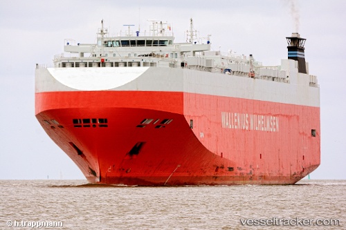
Vessel profile: Taipan is a Vehicles Carrier with dimensions 200m x 32m.
This page combines live AIS, route history, probable destination signals, nearby traffic, and port activity for practical vessel monitoring.
The current position of vessel Taipan is 39.88446 lat / 166.34000 lng. Updated: 2026-06-13 07:47:53 UTCNearest reference points:
- Open sea, approx. 411 nm off the nearest listed port
- Open sea, approx. 413 nm off the nearest listed port
- Open sea, approx. 412 nm off the nearest listed port
Currently sailing under the flag of Bahamas ![]()
Taipan built in 2006 year
Deadweight:
21021 tDetails:
Live Vessel Taipan Analytics (details, animations, etc.)
Recent AIS points (UTC):
2026-06-13 05:14:14 UTC · 39.81167, 167.31332 · SOG 17 kn · COG -1°2026-06-13 06:10:16 UTC · 39.83957, 166.95941 · SOG 17.5 kn · COG 276°
2026-06-13 07:11:11 UTC · 39.86500, 166.57333 · SOG 17 kn · COG -1°
2026-06-13 07:47:53 UTC · 39.88446, 166.34000 · SOG 17.5 kn · COG 275°