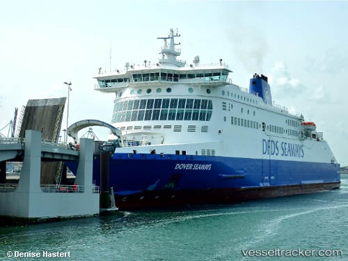
 Dover Seaways
Current Status
Where is the vessel?
Dover Seaways is currently in Near Calais, based on AIS data received about 14h ago.
Latest AIS update:
Current position: 51.03666° N, 1.87523° E (Near Calais)
Average speed (last 7 days): Loading…
Average speed (last 30 days): Loading…
Vessel profile: Dover Seaways is a Passenger Ro Ro Cargo Ship with dimensions 187m x 29m.
This page combines live AIS, route history, probable destination signals, nearby traffic, and port activity for practical vessel monitoring.
The current position of vessel Dover Seaways is 51.03666 lat / 1.87523 lng. Updated: 2026-05-19 16:21:15 UTCNearest reference points:
- Near Calais
- 14 nm SE of RAMSGATE
- Near Sangatte
Currently sailing under the flag of United Kingdom ![]()
Dover Seaways built in 2006 year
Deadweight:
6874 tDetails:
Live Vessel Dover Seaways Analytics (details, animations, etc.)
Recent AIS points (UTC):
2026-05-19 13:10:27 UTC · 51.03499, 1.80002 · SOG 15.8 kn · COG 264°2026-05-19 13:36:27 UTC · 51.05130, 1.62113 · SOG 18.9 kn · COG 276°
2026-05-19 15:56:33 UTC · 51.07685, 1.68717 · SOG 19 kn · COG 132°
2026-05-19 16:21:15 UTC · 51.03666, 1.87523 · SOG 18.4 kn · COG 103°