 Ranger
Current Status
Where is the vessel?
Ranger is currently in Near Heijplaat, based on AIS data received about 14h ago.
Latest AIS update:
Current position: 51.87827° N, 4.42169° E (Near Heijplaat)
Average speed (last 7 days): Loading…
Average speed (last 30 days): Loading…
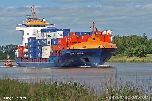
Vessel profile: Ranger is a Container Ship with dimensions 141m x 22m.
This page combines live AIS, route history, probable destination signals, nearby traffic, and port activity for practical vessel monitoring.
The current position of vessel Ranger is 51.87827 lat / 4.42169 lng. Updated: 2026-05-24 16:14:07 UTCNearest reference points:
- Near ROTTERDAM WAALHAVEN
- Near Heijplaat
- Near ROTTERDAM PERNIS
Currently sailing under the flag of Cyprus ![]()
Ranger built in 2005 year
Deadweight:
9288 tDetails:
Live Vessel Ranger Analytics (details, animations, etc.)
Recent AIS points (UTC):
2026-05-24 13:59:08 UTC · 51.87831, 4.42178 · SOG 0 kn · COG 291°2026-05-24 14:23:13 UTC · 51.87821, 4.42183 · SOG 0 kn · COG 289°
2026-05-24 15:48:52 UTC · 51.87821, 4.42175 · SOG 0 kn · COG -1°
2026-05-24 16:14:07 UTC · 51.87827, 4.42169 · SOG 0.1 kn · COG 290°