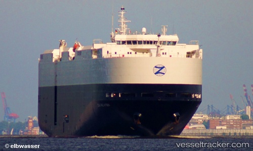
Lake Superior
Current StatusWhere is the vessel?
Lake Superior is currently in 380 nm NW of Caufield North, based on AIS data received about 15h ago.
Latest AIS update:
Current position: 33.28271° S, 9.47575° E (380 nm NW of Caufield North)
Average speed (last 7 days): Loading…
Average speed (last 30 days): Loading…
Vessel profile: Lake Superior is a Vehicles Carrier with dimensions 32m x 183m.
This page combines live AIS, route history, probable destination signals, nearby traffic, and port activity for practical vessel monitoring.
The current position of vessel Lake Superior is -33.28271 lat / 9.47575 lng. Updated: 2026-05-20 19:02:19 UTCNearest reference points:
- Open sea, approx. 402 nm off the nearest listed port
- Open sea, approx. 401 nm off the nearest listed port
- Open sea, approx. 406 nm off the nearest listed port
Details:
Live Vessel Lake Superior Analytics (details, animations, etc.)
Recent AIS points (UTC):
2026-05-20 16:19:19 UTC · -33.15351, 8.83084 · SOG 12.8 kn · COG 107°2026-05-20 16:27:18 UTC · -33.16004, 8.86285 · SOG 12.1 kn · COG 105°
2026-05-20 17:35:06 UTC · -33.21414, 9.13175 · SOG 12.2 kn · COG 108°
2026-05-20 19:02:19 UTC · -33.28271, 9.47575 · SOG 12.1 kn · COG 112°