 vesseltracker.com
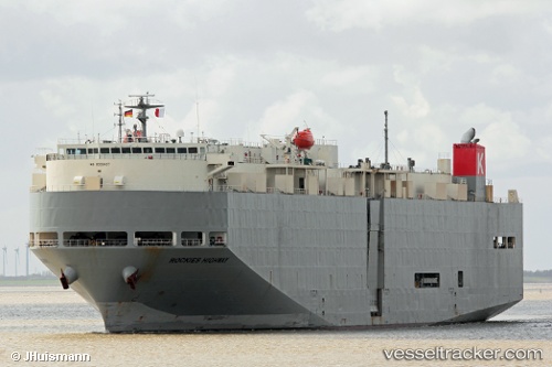
 Rockies Highway
Current Status
Where is the vessel?
Rockies Highway is currently in 14 nm S of JINGTANG, based on AIS data received less than 1h ago.
Latest AIS update:
Current position: 38.98497° N, 119.11775° E (14 nm S of JINGTANG)
Average speed (last 7 days): Loading…
Average speed (last 30 days): Loading…
Vessel profile: Rockies Highway is a Vehicles Carrier with dimensions 183m x 30m.
This page combines live AIS, route history, probable destination signals, nearby traffic, and port activity for practical vessel monitoring.
The current position of vessel Rockies Highway is 38.98497 lat / 119.11775 lng. Updated: 2026-05-15 07:42:34 UTCNearest reference points:
- 19 nm SE of JINGTANG
- Near JINGTANG
- 28 nm SE of JINGTANG
Currently sailing under the flag of Panama ![]()
Rockies Highway built in 2006 year
Deadweight:
12828 tDetails:
Live Vessel Rockies Highway Analytics (details, animations, etc.)
Recent AIS points (UTC):
2026-05-15 04:12:50 UTC · 38.98510, 119.11785 · SOG 0 kn · COG 161°2026-05-15 04:24:42 UTC · 38.98510, 119.11809 · SOG 0.2 kn · COG 159°
2026-05-15 06:09:43 UTC · 38.98522, 119.11873 · SOG 0 kn · COG 190°
2026-05-15 07:42:34 UTC · 38.98497, 119.11775 · SOG 0 kn · COG 171°