 vesseltracker.com
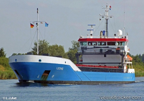
 Leonie
Current Status
Where is the vessel?
Leonie is currently in Near Averlak, based on AIS data received about 1h ago.
Latest AIS update:
Current position: 53.92995° N, 9.20715° E (Near Averlak)
Average speed (last 7 days): Loading…
Average speed (last 30 days): Loading…
Vessel profile: Leonie is a Multi Purpose Carrier with dimensions 90m x 90m.
This page combines live AIS, route history, probable destination signals, nearby traffic, and port activity for practical vessel monitoring.
The current position of vessel Leonie is 53.92995 lat / 9.20715 lng. Updated: 2026-05-16 10:03:05 UTCNearest reference points:
- Near Kiel Canal
- Near Abbenfleth
- Near Stader Sand
Currently sailing under the flag of Netherlands ![]()
Leonie built in 2007 year
Deadweight:
3638 tDetails:
Live Vessel Leonie Analytics (details, animations, etc.)
Recent AIS points (UTC):
2026-05-16 07:30:05 UTC · 54.16968, 9.43276 · SOG 6.7 kn · COG 240°2026-05-16 07:43:04 UTC · 54.15934, 9.39455 · SOG 6.7 kn · COG 247°
2026-05-16 09:35:14 UTC · 53.97180, 9.26411 · SOG 6.9 kn · COG 219°
2026-05-16 10:03:05 UTC · 53.92995, 9.20715 · SOG 6.8 kn · COG 218°