.
Vessel photo of Seri Bakti (IMO 9331634) vesseltracker.com

MY flag Seri Bakti

Vessel type: Lng Tanker | IMO: 9331634 | MMSI: MMSI: 533380000
Call sign: 9MGZ6 | Dimensions: 289 m x 46 m
Current Status

Where is the vessel?

Seri Bakti is currently in 10 nm NW of Sipitang, based on AIS data received about 382d ago.

Latest AIS update:

Current position: 5.14890° N, 115.37811° E (10 nm NW of Sipitang)

Average speed (last 7 days): Loading…

Average speed (last 30 days): Loading…

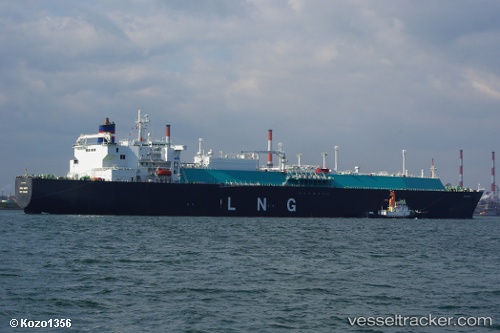
Vessel profile: Seri Bakti is a Lng Tanker with dimensions 289m x 46m.

This page combines live AIS, route history, probable destination signals, nearby traffic, and port activity for practical vessel monitoring.

The current position of vessel Seri Bakti is 5.14890 lat / 115.37811 lng. Updated: 2025-04-13 06:16:50 UTC
Nearest reference points:
  • Near Kota Kinabalu
  • 44 nm SW of Tembungo
  • Near Kikeh

Currently sailing under the flag of Malaysia MY flag

Seri Bakti built in 2007 year

Deadweight:
90065 t

Details:

Live Vessel Seri Bakti Analytics (details, animations, etc.)


Recent AIS points (UTC):
2025-04-13 06:16:50 UTC · 5.14890, 115.37811 · SOG 0 kn · COG -1°

Track of the vessel in the last 60 days


UTC: --
Start: -- Track timeline (UTC) End: --
Encountered: --


Link to the map:


Find another ship

Seri_Bakti (533380000) last ports (portcalls and passsages)

Sipitang | 2025-04-04 01:25:02
PENGERANG | 2025-03-13 06:40:24
LHOKSEUMAWE | 2025-02-27 16:56:28
PULAU SAMBU | 2025-02-26 07:23:24
TANAH MERAH | 2025-02-26 06:09:14
Shimizu | 2025-01-26 22:58:24
BINTULU | 2025-01-18 09:07:54
PENGERANG | 2024-12-31 03:42:28
BATU AMPAR | 2024-12-31 02:45:04
BUKOM ISLAND | 2024-12-30 02:34:13
DAESAN | 2024-12-17 07:46:27
PYEONGTAEK | 2024-12-16 06:57:26
BINTULU | 2024-11-16 18:41:07
Singapore | 2024-09-30 05:04:52
Singapore | 2024-09-11 03:45:23
Sambu | 2024-08-26 09:15:10
Singapore | 2024-08-09 17:33:22
Yokohama | 2024-08-01 06:24:53
Yokosuka | 2024-08-01 05:25:36
Singapore | 2024-07-25 04:12:52
Singapore | 2024-07-03 22:47:59
Gladstone Harbor | 2024-05-26 16:25:49
Osaka | 2024-02-10 02:08:34
Map Ta Phut | 2023-12-02 05:55:20
Yokosuka | 2023-11-15 03:58:48
Kawasaki | 2023-11-15 03:31:18
Gladstone Harbor | 2023-06-03 03:36:17
Gladstone Harbor | 2023-05-05 15:06:29
Gladstone Harbor | 2023-03-27 08:06:52
Shimotsui | 2023-03-13 23:11:16
Sambu | 2023-01-09 05:56:44
Gladstone Harbor | 2022-12-05 02:08:07
Gladstone Harbor | 2022-11-04 02:29:14
Dagu Bar | 2022-10-21 02:07:38
Gladstone Harbor | 2022-10-02 11:08:05
Gladstone Harbor | 2022-08-28 16:09:09
Yokohama | 2022-08-16 01:26:08
Yokosuka | 2022-08-15 23:08:38
Gladstone Harbor | 2022-08-02 19:38:34
Singapore | 2022-07-17 01:31:06
Thursday Island | 2022-07-09 04:17:56
Gladstone Harbor | 2022-07-04 20:19:07
Singapore | 2022-06-04 16:04:19
Yokohama | 2022-04-09 03:50:12
Yokosuka | 2022-04-09 03:23:43
Singapore | 2022-03-01 00:20:14
Das Island | 2022-01-18 02:03:15
Singapore | 2022-01-08 04:40:10
Singapore | 2022-01-08 04:30:09
Singapore | 2022-01-08 03:55:00
Sambu | 2022-01-08 03:40:20
Yokosuka | 2022-01-01 03:45:05
Yokohama | 2022-01-01 03:40:36
Yokohama | 2021-12-31 02:45:49
Yokosuka | 2021-12-31 01:25:29
Selat Wetar | 2021-12-23 06:07:32
Port Darwin | 2021-12-20 21:00:49
Selat Wetar | 2021-12-19 21:56:26
Yokosuka | 2021-12-13 02:46:54
Yokohama | 2021-12-13 02:42:44
Yokohama | 2021-12-12 01:42:03