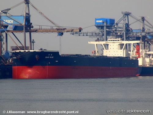
.

Bao Guo

Vessel type: Ore Carrier | IMO: 9336969 | MMSI: MMSI: 370293000
Call sign: 3ESG5 | Dimensions: 50 m x 300 m
Current Status

Where is the vessel?

Bao Guo is currently in Open sea (no nearby ports in database), based on AIS data received about 14h ago.

Latest AIS update:

Current position: 19.56586° S, 4.55643° E (Open sea (no nearby ports in database))

Average speed (last 7 days): Loading…

Average speed (last 30 days): Loading…

Vessel profile: Bao Guo is a Ore Carrier with dimensions 50m x 300m.

This page combines live AIS, route history, probable destination signals, nearby traffic, and port activity for practical vessel monitoring.

The current position of vessel Bao Guo is -19.56586 lat / 4.55643 lng. Updated: 2026-05-20 22:02:54 UTC
More recent position available: 58 min ago
Free positions are delayed by 14 hours.

We recommend registering. If you register, paid vessel access will be saved in your profile. Guest access works only through a personal link.

Nearest reference points:
  • Open sea (no nearby ports in database)
  • Open sea, approx. 441 nm off the nearest listed port
  • Open sea, approx. 442 nm off the nearest listed port
Details:

Live Vessel Bao Guo Analytics (details, animations, etc.)


Recent AIS points (UTC):
2026-05-20 16:11:34 UTC · -18.85327, 4.00819 · SOG 8.9 kn · COG 142°
2026-05-20 17:33:28 UTC · -19.01634, 4.14065 · SOG 8.9 kn · COG 140°
2026-05-20 19:02:34 UTC · -19.19500, 4.28280 · SOG 9 kn · COG 144°
2026-05-20 22:02:54 UTC · -19.56586, 4.55643 · SOG 8.9 kn · COG 142°

Track of the vessel in the last 60 days


UTC: --
Start: -- Track timeline (UTC) End: --
Encountered: --


Link to the map:


Find another ship

Bao_Guo (370293000) last ports (portcalls and passsages)

BUKOM ISLAND | 2025-07-22 15:22:52
PULAU SAMBU | 2025-07-22 14:19:05
TANAH MERAH | 2025-07-21 23:17:45
PENGERANG | 2025-07-21 21:18:05
Subic Bay | 2025-07-16 12:05:59
HANJIN INDUSTRIES | 2025-07-14 11:38:19
HANJIN INDUSTRIES | 2025-07-10 01:05:23
SUBIC | 2025-07-04 02:42:15
HANJIN INDUSTRIES | 2025-07-04 01:48:12
PENGERANG | 2025-06-17 09:45:03
TANAH MERAH | 2025-06-17 08:41:04
BATU AMPAR | 2025-06-17 08:23:21
PULAU SAMBU | 2025-03-18 01:52:17
TANAH MERAH | 2025-03-17 23:02:20
PENGERANG | 2025-03-17 22:12:19
Fangcheng | 2025-03-11 16:56:07
Fangcheng | 2025-03-07 16:03:24
SURALAYA | 2025-02-14 21:44:52
PULAU SAMBU | 2024-11-22 01:24:05
TANAH MERAH | 2024-11-21 05:38:27
PENGERANG | 2024-11-21 04:28:14
Singapore | 2024-07-31 09:01:07
Fangcheng | 2024-07-23 12:55:12
Fangcheng | 2024-07-19 09:25:48
Sambu | 2024-07-12 18:11:26
Singapore | 2024-04-16 18:59:36
Sambu | 2023-12-28 10:45:14
Singapore | 2023-12-27 18:24:30
Qingdao | 2023-12-18 09:56:17
Qingdao | 2023-12-10 17:37:00
Sebang | 2023-08-31 19:01:14
Sambu | 2023-08-29 14:02:28
Singapore | 2023-08-28 23:58:13
Yen-Tai | 2023-08-15 00:55:12
Singapore | 2023-08-03 06:11:42
Sebang | 2023-05-10 08:29:40
Singapore | 2023-05-08 06:14:09
Qingdao | 2023-04-28 11:24:39
Qingdao | 2023-04-24 11:01:56
Singapore | 2023-01-22 06:09:36
Yen-Tai | 2023-01-08 02:57:48
Port Headland | 2022-08-02 23:07:14
Selat Lombok | 2022-06-27 13:54:11
Port Headland | 2022-06-23 07:23:45
Selat Lombok | 2022-05-22 19:13:12
Port Headland | 2022-05-17 23:01:06
Port Headland | 2022-04-08 03:15:55
Wusong | 2022-03-18 18:12:28
Lianyungang | 2022-03-07 08:46:59
Selat Lombok | 2022-02-19 06:56:47
Port Headland | 2022-02-15 05:03:25
Selat Lombok | 2022-01-07 18:57:51
Port Hedland | 2022-01-04 17:36:11
Port Headland | 2022-01-03 12:20:51