 vesseltracker.com
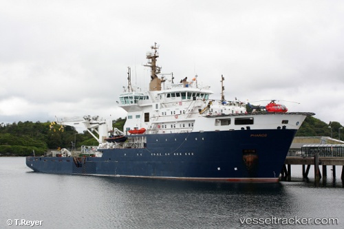
 Pharos
Current Status
Where is the vessel?
Pharos is currently in Near OBAN, based on AIS data received less than 1h ago.
Latest AIS update:
Current position: 56.41184° N, 5.48107° W (Near OBAN)
Average speed (last 7 days): Loading…
Average speed (last 30 days): Loading…
Vessel profile: Pharos is a Buoy Lighthouse Vessel with dimensions 84m x 16m.
This page combines live AIS, route history, probable destination signals, nearby traffic, and port activity for practical vessel monitoring.
The current position of vessel Pharos is 56.41184 lat / -5.48107 lng. Updated: 2026-05-14 22:24:26 UTCNearest reference points:
- Near OBAN
- Near DUNSTAFFNAGE
- Near CRAIGNURE PIER
Currently sailing under the flag of United Kingdom ![]()
Pharos built in 2007 year
Deadweight:
1200 tDetails:
Live Vessel Pharos Analytics (details, animations, etc.)
Recent AIS points (UTC):
2026-05-14 18:09:25 UTC · 56.41184, -5.48107 · SOG 0 kn · COG 292°2026-05-14 19:09:29 UTC · 56.41185, -5.48106 · SOG 0 kn · COG 292°
2026-05-14 19:51:26 UTC · 56.41185, -5.48106 · SOG 0 kn · COG 292°
2026-05-14 22:24:26 UTC · 56.41184, -5.48107 · SOG 0 kn · COG 292°