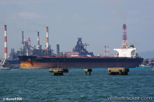
.
Vessel photo of POMPANO (IMO 9346768) vesseltracker.com

LB flag POMPANO

Vessel type: Bulk Carrier | IMO: 9346768 | MMSI: MMSI: 636022205
Call sign: 5LHR2 | Dimensions: 46 m x 288 m
Current Status

Where is the vessel?

POMPANO is currently in Near GANGAVARAM, based on AIS data received about 3h ago.

Latest AIS update:

Current position: 17.62185° N, 83.24040° E (Near GANGAVARAM)

Average speed (last 7 days): Loading…

Average speed (last 30 days): Loading…

Vessel profile: POMPANO is a Bulk Carrier with dimensions 46m x 288m.

This page combines live AIS, route history, probable destination signals, nearby traffic, and port activity for practical vessel monitoring.

The current position of vessel POMPANO is 17.62185 lat / 83.24040 lng. Updated: 2026-03-28 16:15:38 UTC
Nearest reference points:
  • Near Vishakhapatnam
  • Near Wipro Sez/Resapuvanipalem
  • Near Gopalpur

Currently sailing under the flag of Liberia LB flag

POMPANO built in 2006 year

Deadweight:
174219 t

Details:

Live Vessel POMPANO Analytics (details, animations, etc.)


Recent AIS points (UTC):
2026-03-28 09:39:31 UTC · 17.62175, 83.24047 · SOG 0 kn · COG 61°
2026-03-28 11:30:33 UTC · 17.62177, 83.24045 · SOG 0 kn · COG 61°
2026-03-28 13:54:32 UTC · 17.62173, 83.24040 · SOG 0 kn · COG 61°
2026-03-28 16:15:38 UTC · 17.62185, 83.24040 · SOG 0 kn · COG 61°

Track of the vessel in the last 28 days


UTC: --
Start: -- Track timeline (UTC) End: --
Encountered: --


Link to the map:


Find another ship

POMPANO (636022205) last ports (portcalls and passsages)

SALDANHA | 2025-08-30 02:07:23
Saldanha Bay | 2025-08-30 00:47:03
Saldanha Bay | 2025-08-23 19:02:36
Sitrah Anchorage | 2025-08-03 07:49:29
KHALIFA BIN SALMAN | 2025-08-03 06:23:08
MUHARRAQ | 2025-07-31 17:29:25
Sitrah Anchorage | 2025-07-30 07:16:01
KHALIFA BIN SALMAN | 2025-07-30 04:58:46
RAJAEI | 2025-07-26 18:54:08
GAOGANG | 2025-04-21 21:55:49
Taixing | 2025-04-21 20:42:09
Zhangjiagang | 2025-04-21 17:18:26
Nantong | 2025-04-21 14:24:37
Taicang | 2025-04-21 11:27:58
Jingjiang | 2025-04-21 04:58:17
PENGERANG | 2025-04-07 02:21:16
TANAH MERAH | 2025-04-06 08:25:24
Singapore | 2025-04-06 07:13:41
PULAU SAMBU | 2025-04-06 06:11:17
SEPT-ILES | 2025-02-11 07:04:18
SEPT-ILES | 2025-02-07 06:05:06
Strait Of Gibraltar | 2025-01-25 13:23:39
Algeciras | 2025-01-24 18:43:48
MISURATA | 2025-01-18 09:40:25
MISURATA | 2025-01-14 09:33:51
MISURATA | 2025-01-10 09:11:22
TANGER MED | 2025-01-06 05:16:54
Strait Of Gibraltar | 2025-01-06 04:23:56
PULAU SAMBU | 2024-11-06 09:40:54
PENGERANG | 2024-11-05 12:24:58
Taboneo | 2024-10-30 19:56:36
Taboneo | 2024-10-26 20:36:05
Taboneo | 2024-10-22 20:15:55
Taboneo | 2024-10-18 19:34:32
Sambu | 2024-09-22 22:32:36
Saldanha Bay | 2024-08-30 06:58:21
Saldanha Bay | 2024-08-25 00:38:13
Cape Of Good Hope | 2024-08-24 18:09:33
Conakry | 2024-04-11 12:01:13
Strait Of Gibraltar | 2024-04-03 04:51:39
Algeciras | 2024-04-02 16:14:35
Strait Of Gibraltar | 2024-03-07 11:04:26
Tubarao | 2024-02-18 20:32:21
Caldera | 2023-11-11 07:24:14
Caldera | 2023-11-07 07:09:56
Coquimbo | 2023-11-05 22:37:31
Coquimbo | 2023-11-01 21:04:21
Ulsan | 2023-09-27 23:49:31
Algeciras | 2023-05-09 01:29:55
Iskenderun | 2023-04-18 10:03:32
Iskenderun | 2023-04-14 08:34:47
Iskenderun | 2023-04-04 16:24:55
Iskenderun | 2023-03-31 14:14:05
Port Said | 2023-03-29 16:17:03
Singapore | 2023-03-09 14:54:30
Gladstone Harbor | 2023-01-23 23:39:40
Gelibolu | 2022-08-24 10:09:47
Constanta | 2022-07-20 04:44:13
Constanta | 2022-07-16 04:11:36
Canakkale | 2022-07-14 16:15:40
Strait Of Gibraltar | 2022-07-08 16:31:56
Saldanha Bay | 2022-06-20 10:50:03
Saldanha Bay | 2022-06-09 04:30:20
Singapore | 2022-05-17 23:04:10
Sambu | 2022-05-17 22:36:36
Richards Bay | 2022-04-15 09:27:41
Yen-Tai | 2022-02-17 03:58:58
Sambu | 2022-02-03 04:50:40