 Henrik S
Current Status
Where is the vessel?
Henrik S is currently in Near Lianyungang, based on AIS data received about 14h ago.
Latest AIS update:
Current position: 34.81435° N, 119.61738° E (Near Lianyungang)
Average speed (last 7 days): Loading…
Average speed (last 30 days): Loading…
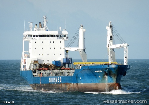
Vessel profile: Henrik S is a General Cargo Ship with dimensions 128m x 18m.
This page combines live AIS, route history, probable destination signals, nearby traffic, and port activity for practical vessel monitoring.
The current position of vessel Henrik S is 34.81435 lat / 119.61738 lng. Updated: 2026-05-20 00:07:03 UTCNearest reference points:
- Near Lianyungang
- 18 nm E of Lianyungang
- 12 nm SE of Lianyungang
Currently sailing under the flag of Panama ![]()
Henrik S built in 2007 year
Deadweight:
11169 tDetails:
Live Vessel Henrik S Analytics (details, animations, etc.)
Recent AIS points (UTC):
2026-05-19 20:16:01 UTC · 34.81549, 119.61606 · SOG 0 kn · COG 66°2026-05-19 21:24:58 UTC · 34.81506, 119.61611 · SOG 0 kn · COG 48°
2026-05-19 23:09:56 UTC · 34.81441, 119.61686 · SOG 0.1 kn · COG 7°
2026-05-20 00:07:03 UTC · 34.81435, 119.61738 · SOG 0.2 kn · COG 349°