 vesseltracker.com
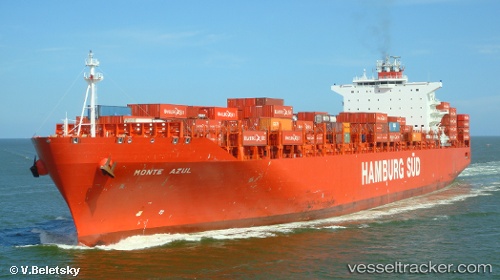
Monte Azul
Current StatusWhere is the vessel?
Monte Azul is currently in 50 nm NE of The Valley, based on AIS data received about 14h ago.
Latest AIS update:
Current position: 18.91060° N, 62.57823° W (50 nm NE of The Valley)
Average speed (last 7 days): Loading…
Average speed (last 30 days): Loading…
Vessel profile: Monte Azul is a Container Ship with dimensions 40m x 272m.
This page combines live AIS, route history, probable destination signals, nearby traffic, and port activity for practical vessel monitoring.
The current position of vessel Monte Azul is 18.91060 lat / -62.57823 lng. Updated: 2026-05-17 22:06:55 UTCNearest reference points:
- Near ST MAARTEN
- Near GUSTAVIA
- 126 nm NE of Sombrero
Details:
Live Vessel Monte Azul Analytics (details, animations, etc.)
Recent AIS points (UTC):
2026-05-17 19:00:59 UTC · 19.29258, -63.33995 · SOG 16.1 kn · COG 118°2026-05-17 19:11:48 UTC · 19.27042, -63.29490 · SOG 15.9 kn · COG 118°
2026-05-17 20:48:58 UTC · 19.07040, -62.89332 · SOG 15.6 kn · COG 120°
2026-05-17 22:06:55 UTC · 18.91060, -62.57823 · SOG 15.5 kn · COG 119°