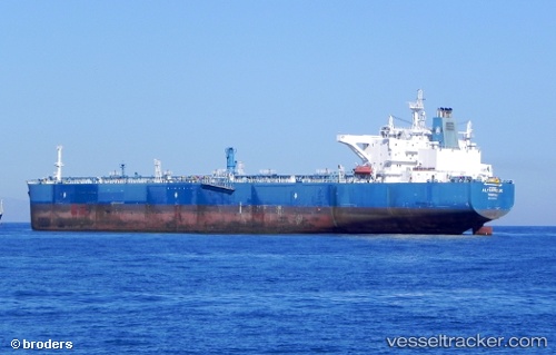
Alyarmouk
Current StatusWhere is the vessel?
Alyarmouk is currently in 61 nm S of Ryuo, based on AIS data received about 14h ago.
Latest AIS update:
Current position: 34.65833° N, 16.72167° E (61 nm S of Ryuo)
Average speed (last 7 days): Loading…
Average speed (last 30 days): Loading…
Vessel profile: Alyarmouk is a Crude Oil Tanker with dimensions 44m x 249m.
This page combines live AIS, route history, probable destination signals, nearby traffic, and port activity for practical vessel monitoring.
The current position of vessel Alyarmouk is 34.65833 lat / 16.72167 lng. Updated: 2026-07-02 15:48:45 UTCNearest reference points:
- 33 nm N of Ryuo
- 73 nm N of Pinelands
- 53 nm NE of Ryuo
Details:
Live Vessel Alyarmouk Analytics (details, animations, etc.)
Recent AIS points (UTC):
2026-07-02 11:12:36 UTC · 33.88500, 17.05667 · SOG 11 kn · COG -1°2026-07-02 12:54:38 UTC · 34.17333, 16.92333 · SOG 10 kn · COG -1°
2026-07-02 14:13:54 UTC · 34.39611, 16.83577 · SOG 10.5 kn · COG 344°
2026-07-02 15:48:45 UTC · 34.65833, 16.72167 · SOG 10 kn · COG -1°